In its purest sense, topography is a look at features of the Earth and natural and manmade formations on Earth. Topographical maps help us get a true sense of an area. They show height changes and features of any area. These maps show us where land elevates or descends and where water forms come into play. Most contour maps, these days, are generated by satellite images. Many satellites have the capability to self-draw these maps. Being able to design and read topographic maps is critical for navigators of marine vehicles and aircraft. These maps tell the navigators safe passages to follow. They can quickly indicate steep slopes or cliffs above and underwater.
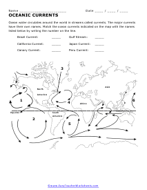
These worksheets will help students learn how to read and interpret contour lines as well as how to draw them. They will also help students explore the natural flow of rivers and waterways. Students will see how that current can help shape landmasses. We will look at how to read a wide variety of maps for location and a perspective about the land we are investigating. The worksheets look at oceanic currents, reading contour and topographical maps, the makeup of river systems, reading all forms of maps, and making your own topographical maps.
Get Free Worksheets In Your Inbox!
Print Topography Worksheets
Click the buttons to print each worksheet and associated answer key.
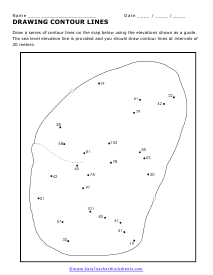
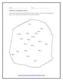
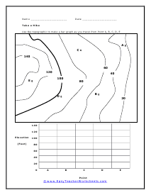
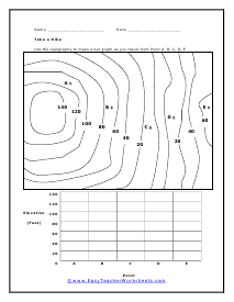
Draw a series of contour lines on the map below using the elevations shown as a guide.
The sea level elevation line is provided and you should draw contour lines at intervals of
20 meters.
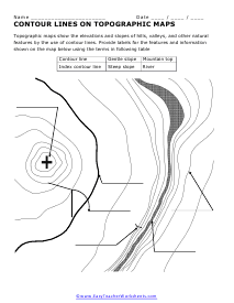
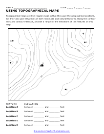
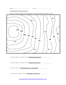
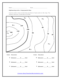
Topographical maps are like regular maps in that they give the geographical positions,
but they also give elevations of both manmade and natural features. Using the contour
lines and contour intervals, provide a range for the elevations of the features on this
map.
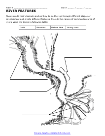
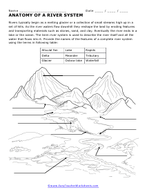
Rivers typically begin as a melting glacier or a collection of small streams high up in a
set of hills. As the river waters flow downhill they reshape the land by eroding features
and transporting materials such as stones, sand, and clay. Eventually the river ends in a
lake or the ocean. The term river system is used to describe the river itself and all the
water that flows into it.
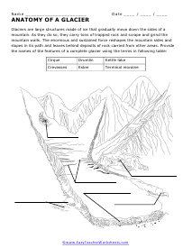
Glaciers are large structures made of ice that gradually move down the sides of a
mountain. As they do so, they carry tons of trapped rock and scrape and grind the
mountain walls. The enormous and sustained force reshapes the mountain sides and
slopes in its path and leaves behind deposits of rock carried from other areas.
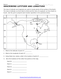
The lines of latitude and longitude are used to locate points of the surface of the Earth.
The lines of latitude run from East to West and the lines of Longitude run from North to
South.
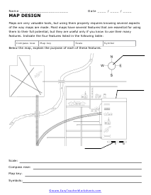
Maps are very valuable tools, but using them properly requires knowing several aspects
of the way maps are made. Most maps have several features that are essential for using
them to their full potential, but they are useful only if you know to use their many
features.
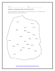
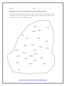
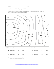
Use the benchmark points below to draw contour lines. The contour lines
should be drawn at 20 foot intervals. When you complete the contour lines,
fill each layer in with a different color. This worksheet has many different reference points to work off of.
Most of us have used digital or paper street maps to navigate when we don't know how to get somewhere, but not everyone has used a topographic map. So, what are these maps?
Topography maps show an area's natural and significant human-made features. These include major roads, urban areas, important buildings, and borders. They also indicate bodies of water, mountains, forests, and valleys.
In the sections below, I'll explain how to understand topography maps and what their colors, symbols, and lines mean.
How To Understand Topographic Maps
I mentioned that topography (or topographical) maps show an area's natural and important human-made features. These features are indicated by a few different markings:
Colors
Lines
Symbols
Once you understand the significance of these markings, they will allow you to understand more about the world around you.
Lines
There are always plenty of lines of topographical maps, and each line type represents something different. Let's take a look at contour lines and other types of lines used to mark topographic features.
Contour Lines
Contour lines are typically wavy and circular and are one of the most important elements of topographical maps. They connect areas with equal elevations, showing where the elevation rises and how steeply.
How widely spaced out they are depends on how steep the land or mountain is. For instance, if the topography map shows a contour line for every 20 feet (6 meters) in elevation, steep mountains will have several tightly-packed contour lines, while flatter landscapes will have fewer.
For every five contour lines, there is an index contour where the elevation is labeled. You can easily spot the index contour because it is slightly thicker and darker.
Other Lines
Other lines on topography maps can vary in color and thickness and can be solid, dotted, or dashed.
Thin, black lines indicate paths and trails, while thick ones show a main road or highway. If you see a dashed line, it's a railway line, but a dotted line shows that an area is relatively flat.
Colors
Topography maps have various colors, including the following:
Brown. Brown areas coincide with contour lines and show features like mountains or hills.
Green. Green-shaded areas show forests, empty tracts of land, and prairies.
Blue. Bodies of water (including oceans, ponds, rivers, and lakes) are shown as blue.
Red or gray. Depending on the topography map, urban areas or cities are shaded in red or gray.
Black. Black symbols or lines indicate human-made structures, such as airports, highways, or roads.
These colors have different shades to denote how built-up or densely populated an area is. For example, a dark red shaded area shows a busy, urban area, while a lighter red shade indicates a suburban area.
Symbols
You will see various symbols and shapes on any topographical map, and many of them are labeled.
For example, you might see a circular shape labeled as “dry lake” or a rectangular shape with a “gravel” label showing that it's a gravel pit.
Buildings are normally shown as small black dots, with large and important ones having their own symbols. Airports are depicted as diagonal crosses, while schools are tiny black squares with little flags on top.
Instead of placing a dot for every building, the map is shaded red or gray in densely-populated areas.
Understanding the Scale of Topography Maps
Since topographic maps usually represent large areas of land, they have a large scale. The U.S. Geological Survey (USGS) uses a scale of 1 to 24 inches (2.54 to 61 cm) , meaning every inch (2.54 cm) on the map shows 24 inches (61 cm) in real terms.
You can check your topography map's scale by looking in the bottom left or right-hand corner.
Topographical maps representing very large areas have larger scales, but maps showing more features in a smaller area have a smaller scale.
Conclusion
Topographical maps show an area's important natural and human-made features, including:
Elevation, such as mountains or valleys
Lakes, rivers, and streams
Major roads and railway lines
Important buildings
Urban areas
After familiarizing yourself with the lines, colors, and symbols mentioned in this article, you should be able to interpret topographic maps and spot interesting features.