
We find ourselves every day using the Global Positioning System (GPS) to get us from where we are to where we are going. This system is based on the measures of latitude and longitude to locate exact points. These worksheets examine the ins and outs of finding the exact location of you spot on the Earth. What does it mean and how do we interpret it? These worksheets start by looking at what each of those imaginary lines represents and how we use them to pinpoint spots on the globe and also in the sense of keeping accurate time where people can enjoy the most daylight. We then look back at the history of navigation and how we travelled the globe prior to Global Positioning Systems. We also take a look at how your latitudinal position dictates the natural resources available to you.
Print Latitude and Longitude Worksheets
Click the buttons to print each worksheet and associated answer key.
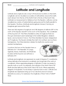
What Are These Lines?
There are 360 degrees of longitude and 180 degrees of latitude (90° to the north of the Equator and 90° to the south of the Equator).

These Lines Multiple Choice Questions
Latitude and longitude are expressed as a pair of degree (°) coordinates where latitude is the horizontal coordinate and longitude is the vertical coordinate.
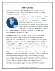
Time Zones
Time zones are regions of the Earth which each observe a uniform standard time for legal, commercial, and social reasons. The Earth is divided into 37 different time zones.
Time Zones Short Answer Questions
All the time zones on the Earth are offset from UTC by a designated number of minutes. Many time zones are offset from each other by exactly an hour.
John Harrison
In 1714, the English government issued the Longitude Act, offering a cash prize to anyone who could solve the problem of determining the precise longitude of a ship while at sea.
John Harrison Questions
John Harrison was a carpenter and a clockmaker. His clocks were remarkably accurate for their time, losing only about one second a month. Harrison determined to win the prize by creating a portable clock that would be accurate to within three seconds a day.
The Longitude Act
Latitude can be measured at sea using the sun, but prior to the 1700s, there was no reliable way of determining longitude at sea.
Longitude Act Questions
Astronomers of the time felt that the best way to measure longitude was to use create a catalog of star positions and then determine longitude by measuring the motion of the moon relative to the stars.
Lunar Distance Method
The lunar distance method was a way of determining longitude at sea by measuring how far the moon had moved in relationship to the stars, much like looking at a hand (the moon) moving across the face of the clock (the stars).
Lunar Distance Method Questions
The lunar distance method required an instrument for making observations and marking angles and accurate charts and tables of moon and star positions.
Latitude and Biomes Reading Passage
A biome is a large geographical area with a unique set of environmental conditions and a unique combination of plants and animals particularly suited to these conditions that live there.
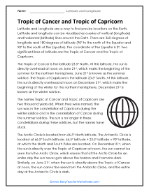
Tropic of Cancer and Capricorn
The Tropic of Cancer is the latitude 23.5° North. At this latitude, the sun is directly overhead at noon on June 21st, which marks the beginning of the summer for the northern hemisphere.
Tropic of Cancer and Capricorn Questions
The Tropic of Capricorn is the latitude 23.5° South. At this latitude, the sun is directly overhead at noon on December 21st, which marks the beginning of the winter for the northern hemisphere.
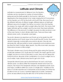
Latitude and Climate
The farther a location is from the Equator, the sharper the angle with which sunlight strikes the Earth. This means that higher latitudes get less sunlight, and thus less heat, than lower latitudes.
Latitude and Climate Short Answer Questions
This difference in the amount of sunlight any given location receives is one of the main factors in what climate exists there. There are three main climate zones: arctic, temperate, and tropic.
Latitude and Multiple Sclerosis
Multiple Sclerosis (MS) is a disease in which the immune system gradually and progressively damages the protective covering of nerves.
Latitude and Multiple Sclerosis Questions
MS can affect the brain, spinal cord, and optic nerves in the eyes and affects everyone who has it differently.
The Prime Meridian and the International Date Line
The International Date Line (IDL), also known as the line of demarcation, is an imaginary line on the Earth's surface that indicates where one day ends and the next day begins.
Prime Meridian and the International Date Line Questions
The International Date Line stretches from the North Pole down to the South Pole.
What Is Latitude and Longitude?
Ever wondered how a phone’s GPS points you to your intended location with just one click? While this involves an enormous amount of scientific work in the background, its most basic element is a standardized coordinate system.
Latitude and longitude make up the geographic coordinate system of the earth that helps us pinpoint specific locations. Latitude is measured relative to the equator, and Longitude is measured relative to the prime meridian. Given longitude and latitude values, we can locate any location on earth.
You might live in a small town just outside of Chicago, Illinois in the United States. You might be able to tell someone that you live in Chesterton next to the downtown Pavilion. Someone who lived locally would understand, but someone from another state or country would have no idea where you are referring to. What if it was critical for that person to locate your position? That is where the geographical coordinate system comes in. Every location on the globe can be located by its position horizontally (latitude) matched with its position vertically (longitude). Latitude is an imaginary line that spans the globe east to west. Longitude is its counterpart and spans north to south. Global addresses are formatted by latitude followed by longitude or a Lat/Long measure.
The following sections explain these two concepts in more detail, so read on to learn more about latitude and longitude!
How Do You Measure Latitude?
As the earth is a sphere, we calculate latitude by measuring its angular distance from the equator. We refer to these angles as northern (N) or southern (S) latitudes, depending on whether they’re measured in a counterclockwise or clockwise direction. These values range from 0º to 90º.
When we draw an angle counterclockwise from the equator, this tells us that the target location is in the upper hemisphere. Hence, we label the angular measurement as the northern latitude.
Meanwhile, measurements drawn clockwise are referred to as southern latitudes. To simplify expressing these values, some prefer affixing a negative sign to the left of the coordinate to pertain to locations in the southern hemisphere.
If only a numerical value is given, it is automatically assumed that the measurement indicates a point in the northern hemisphere.
How Do You Measure Longitude?
Like measuring latitudes, the longitudinal coordinate is based on an imaginary reference point called the Prime Meridian, situated in Greenwich, England’s British Royal Observatory. As latitudes are perpendicular to longitudes, the Prime Meridian is at 90º with the equator.
Longitudinal values can range from 0º to 180º. It is important to note whether this measurement was done in the east or west direction to avoid ambiguity. To do so, we affix either an E (for east) or W (for west) symbol right next to the numerical component of the coordinate.
How Are Longitude and Latitude Expressed?
Longitude and latitude are expressed in terms of degrees or decimal points. Approximately 1 degree latitude or longitude translates to a distance of 111 kilometers (69 miles).
Since we will also need to locate areas that aren't within 111km (69 miles) multiples away from the equator, we have to divide each degree into smaller chunks to describe the location more effectively. Otherwise, the coordinates will be too broad to even be practically useful.
As longitudes and latitudes are angular distances, they are best expressed in degrees (º), minutes (‘), and seconds (“) like the angles of a circle. One degree is equivalent to 60 minutes (60’), while 1’ equates to 60 seconds (60”). Hence, one degree is equal to 3600 seconds. In summary, 1º = 60’ = 3600”
Knowing these conversions, we can alternatively express the geographical coordinates in terms of decimal points. For instance, if our value for latitude is 2º20’20”, simply convert each value into their degree equivalent and add them accordingly:
2º = 2
20’ = 20/60 = .33333
20’’/3600 = 0.00556
Adding all these up gives us 2 + .33333 + 0.00556 = 2.338893. Using an online calculator to check, we confirm that, indeed, 2.338893 is equal to 2º20’20”.
So if we were to write out the coordinates of Washington, DC, for example, they would be expressed as 38°54’25” N for the longitude and 77°2’12” W for the latitude.
Conclusion
Using the Prime Meridian and the equator as reference points, we can locate any place around the globe using the concept of longitude and latitude.
The latitude gives the angular location relative to the equator; the longitude is the angular distance from the Prime Meridian. The intersection of the longitude and latitude pinpoints the exact location being described.